
Illinois Map
|
 |
 |
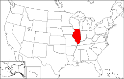
Where Is Illinois?
Illinois is shown in red on the 50 state map to the right. The State of Illinois is bounded by Wisconsin on the north, and by Indiana on the east. It is bounded by Lake Michigan on the northeast, by Kentucky on the southeast, by Iowa on the northwest, and by Missouri on the southwest.
Illinois Maps
Illinois is the 24th largest state in the United States, covering a land area of 55,584 square miles (143,963 square kilometers). The state of Illinois contains 102 counties. This Illinois map site features road maps, topographical maps, and relief maps of Illinois. The detailed, scrollable road map displays Illinois counties, cities, and towns as well as Interstate, U.S., and Illinois state highways. The pannable, scalable Illinois street map can be zoomed in to show local streets and detailed imagery.
Illinois Highway Map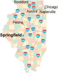 Click on the highway map thumbnail
to view a scalable Illinois road map. |
IL Topo Map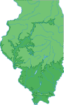 Click map to enlarge.
|
IL Relief Map Click map to enlarge.
|
The detailed Illinois map and the regional Illinois map display cities, roads, rivers, and lakes as well as terrain features. The detailed map shows only the State of Illinois, while the regional map shows Illinois and the surrounding region.
Illinois Infrastructure > Illinois Airports
In 2005, the population of Illinois was estimated at 12,765,427, which is about 229.6 people per square mile. In 2010, Illinois's population rose to 12,830,632 people. More recently, in the 2020 census, the Illinois population was 12,812,508. The state's Interstate Highways include I-39, I-55, I-57, and I-64, as well as I-70, I-80, I-88, I-90, and I-94.
Illinois Topography and Tourist Attractions
The name Illinois is derived from a Native American word that means "tribe of superior men". The flat Illinois terrain is drained by rivers flowing westward to the Mississippi, like the Rock, Illinois and Kaskaskia Rivers. The Sears Tower, the Art Institute, and the Frank Lloyd Wright Home and Studio are popular Chicago tourist attractions, while the Lincoln Home National Historic Site draws visitors to Springfield. For Illinois travel and tourism information, visit the official Illinois tourism site and Illinois Atlas.
Other Illinois Maps
This online Illinois reference map shows major cities, roads, railroads, and physical features in Illinois.Several map publishing companies offer printed maps of Illinois. For example, Omni Resources offers several maps of Illinois that feature points of interest, airports, and parks, as well as selected local attractions and insets of major Illinois cities.
All rights reserved.
Certain maps hereon are © Map Resources or Digital Wisdom.
To facilitate browsing, certain external links will open in new windows.
Illinois-Map.org Editor, State Maps, PO Box 828, Barnegat, NJ 08005.